View Details
Improving the operational safety in Air Navigation A safer airspace
View Details
An improved learning experience
3D training and multipurpose materials
View Details
Civil aviation
Knowing the airspace where the crew flies leads to an increased CRM
(Cockpit / Crew Resource Management)
View Details
Military aviation
A comprehensive approach to the specific needs of military customers when sharing the non-classified operations with the civilian stakeholders
Why air-space3d?
Our unique team of data analysts, 3D graphic designers, video – audio & web technicians,
combined with an ample background in the air navigation services,
offers the best combined option as unified service under one single business.
We are focused in one single objective: to enhance your handling of the aeronautical information,
related to civilian & military operations, with a net impact in saving costs and time.
air-space3d is the answer
We live in a visual world, and today, a mobile visual world
Everything that uses the visual pathway into our brains has a privileged access to our intellectual capabilities. Every day, we humans must remember a smooth flow of data and combine it with a correct decision making process when dealing with our lives…
In aviation, we are tackling situations where every object is moving at speeds exceeding 6-8 miles per minute. When every second counts, there is a thin line we don’t want to trespass: a wrong decision leading to a fatal error.
Fresh, accurate, essential information must be on tap for every operator involved. And that information and training must be revamped periodically, increasing the cost in staff training…
By using extensively 3D visualization, the information is more perfectly ingrained, less easily forgotten and much more available at the right time.
¿The results?: less costs in training, more availability in operation time.
THE OUTCOME
3D visualization is the common factor linking all aspects of our services and products. By shortening the the time and cost invested in understanding the airspace structure, flight path and maneouvres, every applicable scenario receives an extra boost.
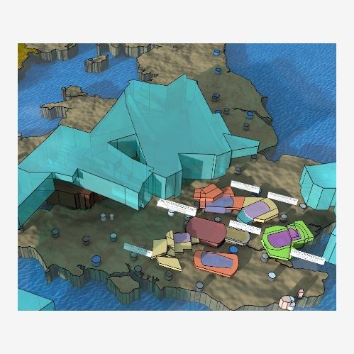
Excerpt from Insignia Enaire.
Flat cartography.
High definition rendered image.
Funcional sectors.
Interpreted from Insigna Enaire
Improvements in training
There’s a net reduction in hourly cost for every step: on-the-job-training instruction (OJTI), advanced, maintenance or new skills instruction.
Security is increased
Applying 3D techniques to cognitive learning, we build an user-friendly interface for our brains to manage the technical data and information.
Airspace enhancement
By offering a new vision to the technical staff, the proposals for new airspaces or changes in the preexisting ones are more easily evaluated, streamlining the decision making process.
Collaboration between administrations and units
Improves the interrelationship between different stakeholders, such as civilians and military (ATC units, government agencies, flight schools, squadrons and bases…) within the operation as a whole (planning, execution and debriefing).
Operation is upgraded
Directly derived from a better collaboration, both normal & special operations (fire-fighting, emergencies, air security details, military exercises, TSA’s & TRA’s, sport activities, etc) receive an extra in day to day development.
Online training
Online training is here to stay, due to its flexibility, modularity and adaptability to the applicable regulations by the National Aviation Authorities.
Is a clear safeguard against situations where staff commuting and travel are not granted, like the current COVID19 pandemic.
Amongst others, 3D visualization has a definitive impact in the ability to access and study the available training material, reducing the time and cost invested in understanding the airspace structure. This improvement can be carried out by the air navigation service provider (ANSP), the ATC unit, the flight school, the military squadron or any other level where the training material is designed
air-space3d
We want you to know us
We are a team of data analysts, graphic designers and multimedia technicians with an ample expertise in air traffic control affairs, and we believe that the aeronautical information user, whether fully qualified or in training, already needed technical, innovative solutions to visualize and interpret the data in a more effective way. For this reason, we are developing a series of products according to our guiding lines.
The products, once built in their initial geometry, are quickly upgradeable in case of change. Depending on the finishing level required (basic geometry, volumes, non-realistic animation, high definition rendered still images/video, with or without fully documented movie), the delivery of updates would be from immediate to two months (intermediate products available earlier).
Research and development are permanent, as our basic catalogue needs to be tailored in accordance with the customer’s needs. The stakeholders are perfectly aware of what problems they have to cover and part of our job is to meet their demand within our scope of practice.
What we offer
All products can be combined among them. Our initial set of products would comprise:
Models
Raw models with all pertaining volumes, sectors and trajectories are available. Sketchup viewer is needed.
We use cookies to ensure that we give you the best experience on our website. If you continue to use this site we will assume that you are happy with it.