USERS OF GRAPHIC INFORMATION IN AIR NAVIGATION SERVICES.
The Air Navigation Services (=ANS) make extensive use of model based information, so we need to determine what staff and teams could benefit from 3D visualization tools. This definition laid out by the European Aviation Safety Agency (EASA) may tell us something about these people. Under the terms “Air Navigation Services” we find included:
- Air traffic services: means the various flight information services, alerting services, air traffic advisory services and ATC services (area, approach and aerodrome control services).
- Communication, navigation and surveillance services.
- Meteorological services for air navigation.
- Aeronautical information services.
Permanent links:
https://www.easa.europa.eu/faq/45957
https://eur-lex.europa.eu/legal-content/EN/ALL/?uri=CELEX:32004R0549
At first glance, a variety of people and positions could take advantage of using advanced techniques when learning and working with model based data.
GRAPHIC INFORMATION CURRENTLY AVAILABLE.
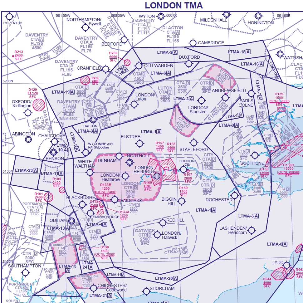
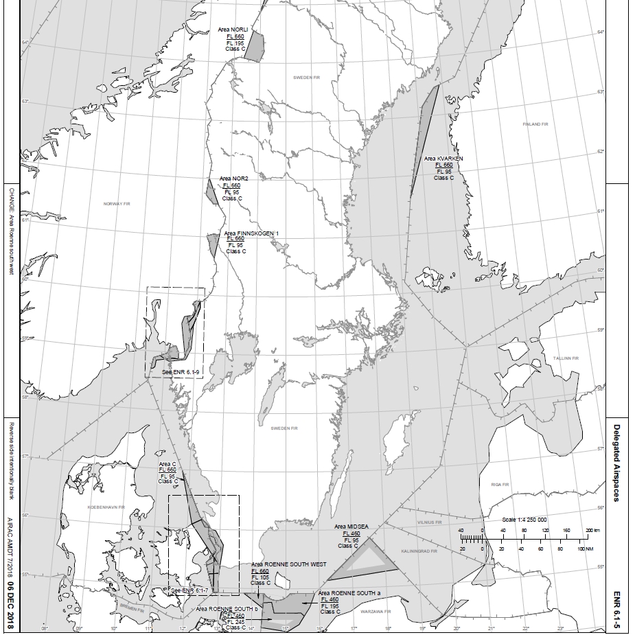
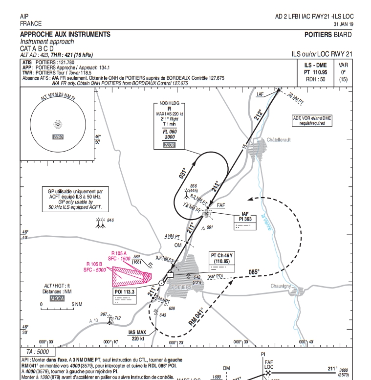
As per the ICAO standards and recommendations to which every ANSP (=Air Navigation Service Provider) adheres, it is expected to find similar charts and graphics. Let’s see some examples.


GIS: A POSSIBLE ANSWER?
Every aircraft moves inside a 3D environment without fixed references, hence the term “to navigate”. As Air Navigation Services are linked to the terrain, i.e., “georeferenced”, an initial approach for a higher role of graphic information in the ANS could be the GIS way, which in itself is a complex world full of tools and possibilities.
Geographic Information Systems or GIS is a concept dated back to 1960, currently included in everyday applications like Google Earth with its location-based search facility. Both a tool and a science, GIS is currently present in many decision making processes, with its powerful features of data analysis and mapping products. Further information is available with a simple Google search. Its many capabilities can be checked out in ESRI website, one of the main GIS manufacturers:
What is GIS? | Geographic Information System Mapping Technology (esri.com)
GIS in Transportation | Solutions for Operational Efficiency (esri.com)
Airport Operations | Improve Operational Performance in Real Time with GIS (esri.com)
GIS DISADVANTAGES.
But as powerful as they are, GIS also have many drawbacks.
1. Usability and affordability. GIS software is expensive and may be difficult to use. Besides the hardware and the software, there is need to have a fully trained human personnel that is expensive to train and acquire.
2. Analysis bias. The main purpose of GIS is to get conclusions out of a set of structured data. For that, complex data structures are used, with plenty of definition and restructuring required. This means that special skills are required to understand and interpret the data collected in a GIS system.
3. Large amounts of data: A GIS system stores extremely large amounts of data at any given time. This may create problems when it comes to analysis due to the complexity of the data and the risk of generalization. It also creates problems when it comes to interpretation. The data collection process using a GIS system is usually expensive in the long run since not all the data collected will be useful and yet all require storage and analysis.
4. Large storage: GIS data requires extremely large storage space due to the large data sizes and data types used. This also increases the cost of storage and the manpower required to manipulate the data to make sense.
5. User friendliness. GIS data require complex overlay operations that are difficult to achieve especially when the personnel involved are not properly trained. Unlike other forms of data analysis techniques, the data captured in a GIS system is usually less “pretty” or impressive, leading to some level of difficulty or complexity in the analysis of the data that would otherwise have been easy. The presentation of the data in GIS system may also not be organized for easy end-user consumption.
WORKLOAD.
A lot of research has been done in the field of human factors in air navigation. Among some other groups, the air crews and the air traffic controllers are two of the most demanding and specialized staffs, regarding selection, learning, training and working. Let’s see some notes about each one.
Regarding the air crews, we may quote “Analysis of the flight task around different types of aircraft”, by Marie Lacabanne, Franck Amadieu, André Tricot and Nathalie Spanghero-Gaillard:
[…] “The pilot evolves in three types of environment:
1) An organizational environment, i.e. a set of constraints that can be imposed by the airline, the government, or even the armed forces for the military aviation.
2) An operational environment, i.e. a set of constraints that can be imposed by the controllers and the air traffic management.
3) A physical environment in which the aircraft is flying (turbulence, precipitation, ground or in flight obstacle, etc.)
To evolve in these environments, the pilot has to perform four meta-tasks, which are:
- Aviate: control the aircraft’s flight path.
- Navigate: direct the airplane from its origin to its destination.
- Communicate: provide data and request and receive instructions and information.
- Manage: manage the resources available (fuel, temperature, oil, etc.).
The tasks have not the same priority, the aviate and navigation tasks being considered as more priority than communicate and manage”.
Source:
“Analysis of the flight task around different types of aircraft”
On the other side, for air traffic controllers at least six main activities can be identified:
- Situation monitoring
- Resolving aircraft conflicts
- Managing air traffic sequences
- Routing or planning flights
- Assessing weather impact
- Managing sector/position resources
These main areas include 46 sub-activities and 348 distinct tasks. For example, the relevant cognitive/sensory attributes required for high performance levels at radar workstations are spatial scanning, movement detection, image and pattern recognition, prioritizing, visual and verbal filtering, coding and decoding, inductive and deductive reasoning, short- and long-term memory, and mathematic and probabilistic reasoning.
Source:
H.L. Ammennan, L.J. Bergen, D.K. Davies, CM. Hostetler, E.E. Inman and G.W. Jones.
FAA air traffic control operations concepts, Vol. VI. AKTCC/HOST En route controllers, report number DOT/FAA/AP/86-01 (Washington, Federal Aviation Administration, 1987.
Some factors could be derived as “common” when comparing air crews and ground crews. One of these factors is the need for situational awareness and its relation with human information processing.